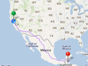
On my iPhone, I'm looking at a map with a dot on a road in a foreign country. The dot says 2480 miles. That's here to there. As crow flies, I imagine.
That's a long way.
It's an odd thing how technology plays with your conception of distance. Places are never so far apart as they used to be. Phone calls and letters, time zones and zip codes... In these days of Skype and Facetime, where everyone has a cellphone and a chat account, where your days' activities are updated in 140 characters or less and fed instantly to countless people, well, the distance from here to there is cross-able.
I stare at the dot on the map some more, blinking along on Bullet Tree Road1 in some jungle somewhere.
2482 miles.
On the other hand, you know exactly how far it is. “There” was once so inconceivable as to be irrelevant. It was functionally the distance between here and the mailbox, or here and the telephone. Not anymore. “There” is on the map with the blinking dot. And here's my dot way over here. And there's half a world in the middle, in conveniently resolved map tiles.
2484 miles.
Places like Belize aren't just names on the airport arrival gate anymore. (Not that security lets you get a visual on the gate these days; they prefer to violate the human rights of ticket holders only in this brave new world, but that's a rant for another time.) Now someplace like Belize is papayas and monkeys and pictures from the bottom of the ocean sitting in the palm of your hand. Yes, I know this information was always available, at the library, or deep within the dusty volumes of the Encyclopedia Brittanica that lined one wall of shelves at grandma's house. But the difference is, now, we actually bother to look it up. It's very nearly compulsive. Almost involuntary. "Consult the oracle," as a friend of mine says, and a room full of people are digging around in their pockets for their own personal magic mirror to see the world.
2485 miles.
You know what's funny? I look at those numbers and wonder about margin of error. Perhaps it's my industry kicking in, that I go looking for the HDOP before I trust the numbers. There's a glowing sphere around the bubble that bobs along the road on the map which is supposed to represent the dot's margin of error, but we've all found ourselves outside that glowy sphere from time to time. I look at 2845 miles and think, probably off by a few meters. Maybe even kilometers. And I'm translating the difference between kilometers and miles in my head before I intend to.
Little dots have no comforting timber to their voice. They don't have a smell or a taste or a touch. It's just a little dot, from Google's default symbology set, font-size:8px, font-color:#FF0000.
And it's on the other side of the world in full satellite color.
______________________________
1) Not a comforting name
Comments
Sounds like you have a loved
Sounds like you have a loved one in a jungle in Belize...hope your dot gets back home soon.